
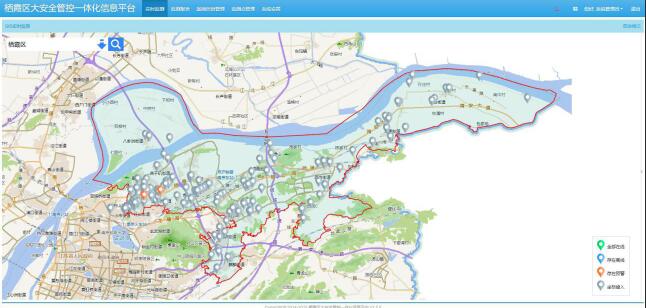
1. Real time monitoring: The platform receives and summarizes all monitoring data, relying on powerful GIS functions to visually display the entire pipeline operation status on the map.
2. Warning and alarm: When an alarm is detected, it can accurately locate the location of the leak or damage, issue an alarm prompt, and accurately display the location of the alarm point on the GIS map, guiding maintenance personnel to quickly troubleshoot the problem.
3. Operations management: The platform focuses more on the process information that generates results, so it can ensure the accuracy of the information. In addition, this information can also provide a good foundation for further refined data analysis and processing, which helps to continuously improve operations management.
4. Report Center: The platform realizes the formation of unified reports for pipeline monitoring equipment information, monitoring data, alarm data, and operation and maintenance data, and outputs and prints them.
5. System Information: Implement management of system menus, user management, role management, system parameter settings, device configuration, system settings, and more.
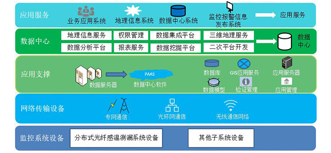
Ordinary remote software is based on C/S architecture and can only be used for local or remote installation of this software on industrial computers to view system data. It cannot be viewed on other industrial computers and devices. And the system is only for fiber optic temperature measurement leakage monitoring and cannot be connected to other systems. In addition, ordinary temperature measurement software does not have a GIS geographic information positioning system, only ordinary electronic maps.
The main advantages of a comprehensive software platform are:
1. The comprehensive software platform is a B/S architecture, and the system status can be viewed in real time by entering an IP address and password through a webpage on any terminal.
2. The software platform has GIS functionality and can accurately locate based on latitude and longitude, combined with maps. The unique geographic spatial analysis capability, fast spatial positioning search and complex query functions, powerful graphic processing and expression, spatial simulation and spatial decision support of GIS can generate important information that is difficult to obtain by conventional methods, which is an important contribution of GIS.
3. The integrated software platform can also be connected to other management and monitoring systems to achieve unified management of big data.
 Sales line:4008-555-919
 Contact address:Room 302, Floor 3, Building No. 3, No. 38 Courtyard, Linfeng'er Road, Haidian District, Beijing
 E-mail:market@dsc.net.cn Contact phone number: 010-82403194 Mobile phone number:15201662379
